Price Reduced39

$539,900
6 bd · 3 ba · 2,811 sqft
8 Westland St, Worcester, MA
TOPP Realtors · OWN IT

No listing photos
5
Beds
3.5
Baths
2,673
Sqft
1906
Year built
Range $594,048 – $662,312 · as of October 21, 2026
ATTOM automated valuation model · 55 published estimates over 6.8 years · shaded band is the model's own published low-to-high range
Highest reading $723,750 in May 2025; lowest $388,123 in January 2020. The vertical scale starts at the series' own low, not at zero — it is drawn to show movement, not absolute size.
$125,636
Estimated monthly payment
$4,131/mo
Loan amount $502,544. Estimate only — your actual rate and payment depend on credit, location, and lender.
2026 roll
MLS Property Information Network (MLS PIN)Some properties which appear for sale on this web site may subsequently have sold or may no longer be available.
Price Reduced39$539,900
6 bd · 3 ba · 2,811 sqft
8 Westland St, Worcester, MA
TOPP Realtors · OWN IT
 42
$738,500
5 bd · 4 ba · 2,945 sqft
49 Berwick Street, Worcester, MA
Jeff Burk · RE/MAX Vision
 37
$675,000
4 bd · 3 ba · 2,186 sqft
6 Saxon Rd, Worcester, MA
Joseph Abramoff · BA Property & Lifestyle Advisors
 Price Reduced39
$485,000
4 bd · 2 ba · 1,850 sqft
41 Drexel St, Worcester, MA
Lynda Hafner · ERA Key Realty Services- Spenc
 Price Reduced40
$647,500
4 bd · 3 ba · 2,882 sqft
28 Maplewood Rd, Worcester, MA
Cynthia Klocek · Coldwell Banker Realty - Worcester
 39
$549,000
4 bd · 3 ba · 2,156 sqft
56 Berwick St, Worcester, MA
Michael Curtis · Coldwell Banker Realty - Worcester
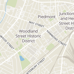
Rings at ½ mile and 1 mile. Basemap © OpenMapTiles © OpenStreetMap contributors.
Open the Worcester camera map1 license-plate reader mapped within 1 mile of this home. None within ½ mile. Nearest: 0.9 mi southeast. Operator named in the data: Worcester Police.
| Device type | Within ½ mi | Within 1 mi |
|---|---|---|
| License-plate readers | 0 | 1 |
Community-reported via OpenStreetMap; may be incomplete. Data as of . © OpenStreetMap contributors (ODbL)
License-plate readers (ALPR) are fixed cameras that photograph passing vehicles and read their plates. Records are typically shared with the agency or association that operates the camera.
School ratings (A+ to F) from HJN community data.
Midland Street
KG-6 · Regular · Worcester School District
249 students · 13.6:1 student–teacher
Doherty Memorial High School
9-12 · Regular · Worcester School District
1,573 students · 15.3:1 student–teacher
Worcester Dual Language Magnet School
PK-6 · Regular · Worcester School District
519 students · 11.6:1 student–teacher
May Street
KG-6 · Regular · Worcester School District
310 students · 14.3:1 student–teacher
Flagg Street
KG-6 · Regular · Worcester School District
412 students · 18.3:1 student–teacher
Notre Dame Academy
7-12 · Regular
243 students · 6.0:1 student–teacher
Tatnuck
PK-6 · Regular · Worcester School District
376 students · 13.6:1 student–teacher
Worcester Seventh-Day Adventist School
2-8 · Regular
20 students · 10.0:1 student–teacher
Within 2 miles of this home: 38+ restaurants and cafés, 12 grocery stores, 38+ parks and green spaces, and 8 transit stops.
Place data from OpenStreetMap.
Espress Yourself Coffee
Richmond Avenue
Westside Steak and BBQ
Newton Square Pizza
Pleasant Street
Loving Hut
International restaurant · Chandler Street
Sullivan Commons Woo Cafe
Nancy Chang's
Chinese restaurant
Chandler's Juice and Smoothies
Nu Kitchen
American restaurant · Chandler Street
Star Mini-Market
Market 32
Park Avenue
Big Y
Ed Hyder's Mediterranean Marketplace
Uncle Sam Market
Pleasant Street
America's Food Basket
May Street
Cebao Market
Main Street
BCP Electric LLC
Jackson Street
Newton Hill at Elm Park
IUI Garden for the Ages
Lake Ellie
General Foley Stadium
Beaver Brook Dog Park
Rockwood Field
Beaver Brook Playground
Elm Park
Mower St
30 The Trolley Stop
30
8/30/31 Gold Star Blvd/Chadwick St
8/30/31 Grove St/Chadwick St
Main St. + Crystal St
Union Station Hub
Foster Street
Worcester Bus Station